Walks 2012
Note: This page includes tracks and photos for walks with friends and family in 2012. Use the menu at the top of the page to display Walks with the Horizons group, walks for other years, and for maps which group tracks by mountain range.
Note: the figures for
accumulated climb in the "Walk profile and statistics" are not always
accurate, due to an incorrect GPS setting.
Walks 2012
- 13-Aug-12: Chartreuse: Cabane de
Bellefont
(1633m) et le Chaos de Bellefont, à partir de Perquelin (998m), 10,4km,
avec Benjamin et Myléna
Altitudes: mini 998m, max 1723m, accumulated 782m
- Tracé
de la balade
- Profile et statistiques de la balade
- Télécharger le fichier
gpx
- Photos
- 27-Aug-08: Chartreuse - Col de Bellefont and Lance Sud de Malissard, starting from Les Essarts (1418m)
- Tracé
de la balade
- 1-Aug-12: Vercors: Col de l'Arc et le Pic
St Michel (1966m), à partir des Barnets (1285m), 8.5km, avec Timothée
Altitudes: mini 1281m, max 1966m, accumulated 740m
- Tracé
de la balade
- Profile et statistiques de la balade
- Télécharger le fichier
gpx
- Photos
- Tracé
de la balade
- 26-Jul-12: Belledonne: Lac Blanc
(2170m),
à partir du Pré Marcel (1304m), 13.8km, avec Jacques
Altitudes: mini 1304m, max 2175m, accumulated 1154m
- Tracé
de la balade
- Profile et statistiques de la balade
- Télécharger le fichier
gpx
- Photos
Voir aussi la randonnée avec le groupe Horizons:
- Tracé
de la balade
- 2-Oct-08: Belledonne - Lac Blanc
- 12-Jul-12: Perigord: La Balade du
Colombier, starting from Bournel, 6.3km
Altitudes: mini 80m, max 153m, accumulated 157m
- Track
display
- Profile and statistics for the walk
- Télécharger le fichier
gpx
- Photos
- Track
display
- 21-Jun-12: St Tropez peninsula:
Cap
Camarat, starting from l'Escalet, 7.3km
Altitudes: mini 4m, max 41m, accumulated 256m
- Track
display
- Profile and statistics for the walk
- Télécharger le fichier
gpx
- Photos
- Track
display
- 19-Jun-12: St Tropez peninsula:
Cap
Taillat, starting from Gigaro, 13.5km
Altitudes: mini 0m, max 106m, accumulated 335m
- Track
display
- Profile and statistics for the walk
- Télécharger le fichier gpx
- Photos
- 28-Jun-11: St Tropez peninsula: Cap Taillat
- 1-Jul-10: St Tropez peninsula: Cap Taillat
- 28-Jun-10: St Tropez peninsula: Cap Lardier
- Track
display
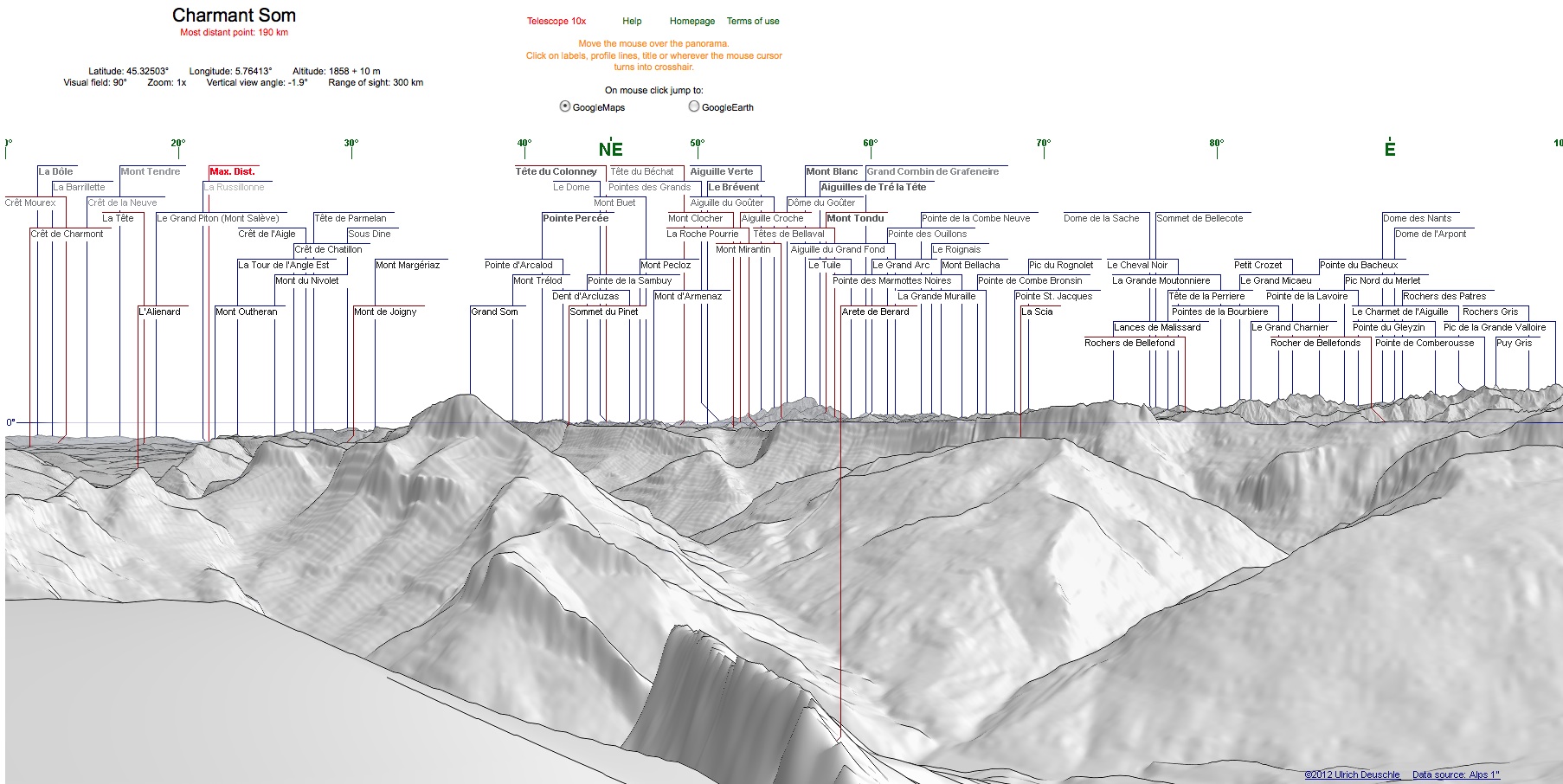
- 27-Feb-12: Chartreuse - Charmant Som
(1867m) starting from Col de Porte (1347m), 13.3km
Altitudes: mini 1324m, max 1884m, accumulated 739m
Climbed up via Plénum and the Crête de Montfromage, descent via the road.
Click on an image to enlarge it

Grand Som, Mont Blanc, Lances de Mallisard, ...
Photos taken from the summit of Charmant Som, Lat 45.32502, Long 5.76412, Altitude 1883m

Panorama centred on 55 deg
Generated for the same point as above from the web site 'Generate a Panorama'
- Track
display
- Profile
and statistics for the walk
- Download the gpx
file
- Photos
- 8-Mar-08: Chartreuse - Col de Porte to Le Montfromage
- 19-Jan-08: Chartreuse - Col de Porte to Le Montfromage.
- Track
display
- 22-Jan-12: Vercors - Vallon de la
Fauge,
à partir de Villard-de-Lans (1015m), 8.2km, avec Jean-Louis
Altitudes: mini 1014m, max 1363m, accumulated 384m
- Tracé
de la balade
- Profile
et statistiques de la balade
- Télécharger le fichier
gpx
- Photos
- Tracé
de la balade